Attribution science
Attribution study finds Canada's peak fire week is now five times likelier than in a cooler climate
A World Weather Attribution report dated 6 August 2026 finds the worst week of fire weather in the Northwest Territories is now about five times likelier than in a climate 1.4 degrees cooler, its return period falling from 50 years to two. Over 3 million hectares burned, 94 per cent of it in five weeks.
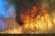
A team of scientists from Canada, the United States, the Netherlands and the United Kingdom published an attribution analysis on 6 August 2026 concluding that human caused warming has sharply raised the odds of the fire weather behind Canada's 2026 season. The report, issued by the World Weather Attribution group and deposited under the digital object identifier 10.25560/131764, covers a season in which more than 3 million hectares had burned by early August, with 94 per cent of that area lost in the five weeks from late June to late July. Canada's national preparedness level reached 4, its highest tier.
The study did not attribute the fires themselves. It attributed the weather that made them possible, using the Daily Severity Rating, a scaled power transformation of the Canadian Fire Weather Index, alongside fire radiative power measured by the VIIRS satellite instrument. Two windows were tested: the most severe seven day stretch of the season, written DSR7x, and the most severe thirty day stretch, DSR30x.
In the Northwest Territories the seven day peak is now expected roughly once every two years. In a climate 1.4 degrees cooler, the report finds, the same week would have been a once in fifty year event. The thirty day peak has moved from roughly once a century to once every six years.
Ontario's figures are smaller but point the same way. The seven day peak there carries a current return period of about fifteen years and is judged around 3.5 times likelier than in the cooler climate, while the thirty day measure came out at roughly eight times likelier on the observational record.
Here the report's own lines of evidence pull against each other, and the authors say so. When the observed record is combined with climate model simulations, the headline numbers come down. The synthesis gives about a fivefold increase for the Northwest Territories seven day measure and about a doubling for the thirty day measure, and about a doubling for both Ontario measures. The observations alone imply a larger shift than the models will support, and the published result is the more conservative combined figure.
The report also carries a negative finding that cuts against a common assumption. Long running dryness preceded the fires, but the authors write that there is no evident trend in the climate models, and that they therefore cannot attribute a change in 24 month dry conditions to human induced climate change. Warming loaded the short term fire weather. On the multi year drought, this evidence does not reach.
Independent monitoring supports the scale. NASA's Earth Observatory recorded roughly 850 active fires across Canada on 14 July 2026, more than 180 of them in Ontario, with 1.9 million hectares burned nationally by that date, in imagery captured by the VIIRS instrument aboard the NOAA-21 satellite. The Copernicus Atmosphere Monitoring Service reported on 17 July that Ontario's fires had already produced the highest annual total carbon emissions recorded for the province, while Canada as a whole remained below its 2023 and 2025 totals. World Weather Attribution puts the number of people exposed to dangerous air quality across the United States Midwest and Northeast above 120 million, and notes that Indigenous communities were overrepresented among those displaced.
A wider figure complicates the picture rather than softening it. Copernicus reported on 6 July that global biomass burning emissions for January to June 2026 came in just below 400 megatonnes of carbon, the lowest first half total in a 24 year record, with Africa contributing about 154 megatonnes and Asia about 113. Boreal Canada and Russia were the exception, climbing quickly from late June. A quiet global year and a record provincial one are not in conflict. They describe different things.
The Canadian analysis is the second wildfire attribution the group has published this southern winter. On 30 July it found the conditions behind fires in central Spain at least 20 times likelier because of warming, and those in southwest France at least twice as likely, after roughly 140,000 hectares burned in Spain and 115,000 in France, with 220,000 people evacuated on the French side. For Australia the direction of travel is established but not event specific: the 2024 State of the Climate report from CSIRO and the Bureau of Meteorology records an increase in extreme fire weather and a lengthening fire season across large parts of the country, against a long run national average of more than 8,000 wildfires and about 2.1 million hectares burned each year in Canada, roughly 85 per cent of that area lit by lightning.
What is not settled: the group's public page does not name its authors, state a peer review status, or list which climate models entered the synthesis, and the deposited report could not be opened at the time of writing. Nor does the analysis say how much of Canada's burned area would have been avoided in a cooler climate. Attribution of fire weather is not attribution of fire. Ignition, fuel load, forest management and suppression capacity all sit between the two, and this study does not measure them.
Sources
Every factual claim above rests on the 8 published sources below. They are listed so you can check the reporting rather than take it on trust.
- World Weather AttributionClimate change means extreme fire seasons in Canada are here to stay
- World Weather AttributionClimate change increases likelihood of compounding drivers of severe wildfire conditions in France and Spain
- World Weather AttributionWorld Weather Attribution study index
- Copernicus Atmosphere Monitoring ServiceExtreme wildfires in Canada lead to severe air pollution in the United States
- Copernicus Atmosphere Monitoring ServiceLowest global biomass burning emissions on record during the first half of 2026
- NASA Earth ObservatoryOntario Wildfire Smoke Moves East
- Natural Resources CanadaWildland fires
- CSIROState of the Climate